Exploring the Hidden Beauty
Beneath Pulau Perhentian
By Azizi Ali (INOS)
5 Days of Habitat Mapping Adventure
From clear blue skies to calm turquoise waters, our recent 5-day trip to Pulau Perhentian was not just for work – it was an experience to remember! Our mission? To explore and map the amazing underwater habitats around this island paradise, using scientific tools that help us “see” what’s under the sea.
Each day started early with laughter and coffee, and by 8 a.m. we were already out on the boat, cruising over the gentle waves. Our team used special equipment like a multibeam system and GPS to map the seafloor, capturing images of coral reefs, sandy patches, rocky areas, and more.
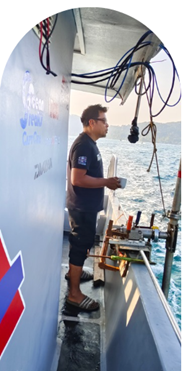
Day 1: Gears On, Let’s Go!
We kicked off our mission by setting up all the high-tech equipment onboard—computers, sonar screens, and survey software. With coffee in hand and the sea breeze in our hair, we began scanning the seafloor, watching live sonar images appear on our monitors. It was like watching a treasure map being drawn in real time!
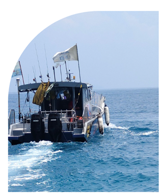
Our Floating Lab: Terminal 53 on Duty
Meet Terminal 53—our bold, colourful, and trusty vessel that carried us through five days of sea adventures around Pulau Perhentian. More than just a boat, it became our floating lab, office, kitchen, and rest stop all rolled into one.
From sunrise surveys to sunset reflections, Terminal 53 never failed to keep us steady and safe while we mapped the marine habitat. She turned heads wherever she went—and for good reason!
☕ Morning Calm Before the Mapping Begins
There’s something special about sipping a hot cup of coffee while watching the ocean roll by. Every morning on our 5-day trip began with this peaceful ritual—standing at the side of the boat, mug in hand, feeling the breeze and soaking in the calm before the workday kicked off.
It wasn’t just coffee—it was a quiet moment to reflect, laugh with teammates, and get ready for another day of adventure beneath the waves. Science may be serious, but a little serenity (and caffeine!) goes a long way.
Day 2: Calm Seas, Clear Data
We covered a large section of reef on the east side of the island. The sea was calm, the sun was kind, and the data looked beautiful! It felt amazing watching the seafloor take shape with every pass we made.
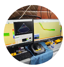
Mapping the Seafloor—One Line at a Time
Inside our boat’s mini control room, this setup became the heart of our habitat mapping operations. Three bright monitors displayed live sonar data as we cruised around Pulau Perhentian. What looks like colourful patterns and graphs is actually the shape of the seafloor beneath us—captured using multibeam sonar.
Each green and orange patch tells us whether the bottom is sandy, rocky, or reef-covered. It’s like painting an underwater landscape without ever diving in!
From here, we could monitor our coverage, guide the boat, and ensure no area was missed. It may look high-tech (and it is!), but it was all about teamwork, focus, and curiosity.
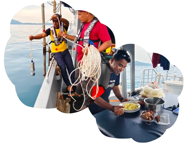
DAY 3: ROPE, READINGS & ROTI! Things got a bit rocky with stronger waves, but our crew was unfazed. We collected oceanographic readings using CTD sensors while enjoying freshly packed nasi goreng and fried chicken. Fieldwork fuel at its best!
Lunch with a View: Fuelling the Science Nothing beats a good plate of nasi goreng after hours under the sun—especially when served right on the deck with the sea as our dining hall. Meals were full of smiles, stories, and shared laughter that kept our spirits high.
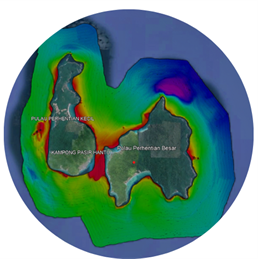
DAY 4: MAPPING & MAGIC MOMENTS We surveyed near the rocky shores and captured detailed multibeam bathymetry. As the day ended, nature gave us a stunning sunset that silenced everyone—a perfect reminder of why we do what we do. 🗺️ What Lies Beneath: Mapping the Seafloor Around Pulau Perhentian
This striking map shows the underwater terrain around Pulau Perhentian Kecil and Pulau Perhentian Besar. The colours represent depth—ranging from shallow coral reefs in red and yellow, to deeper waters in blue and purple.
Using multibeam sonar technology, our team collected thousands of data points to build this detailed image of the seabed. It helps us identify habitat types, reef boundaries, and suitable areas for marine protection and research.
From the vibrant shallows near Kampung Pasir Hantu to the deeper trenches offshore, every colour tells a story of the marine environment beneath the surface.
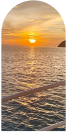
Golden Farewell: A Sunset to Remember
As our final day at sea came to a close, nature gifted us with this breathtaking sunset off the coast of Pulau Perhentian. The golden hues reflected over calm waters served as the perfect ending to five fulfilling days of mapping the hidden wonders beneath the waves. It wasn’t just a view—it was a quiet reminder of the beauty we’re working to protect.