What is coastal upwelling?
Coastal upwelling is a natural process that cause horizontal divergence on the sea surface, which force the water from the deeper layer to ascend to the surface layer.
How does it occur?
The combined effect of Earth’s rotation and frictional force coupling between wind and surface water (Ekman transport) results in the net transport of water at about 90° directed to the right of the wind direction in the Northern Hemisphere. Coastal upwelling occurs as the Ekman transport moves the surface water offshore and the underneath water wells up to replace the lost of surface waters.
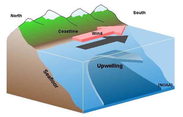 Figure 1: During upwelling, alongshore wind pushes surface water offshore (image adapted from NOAA website).
What is the impact of upwelling in the marine environment?
In the normal condition, nutrients in the surface layer are generally limited. This condition is contradict to the underneath waters where the nutrients are often higher. As upwelling took place, the nutrient are being drawn up from the deeper layer to replenish the nutrient-depleted surface waters which are essential for the marine life.
Coastal upwelling often result in the increase of fishery productions. Although upwelling areas only occupy about 0.1% of the world’s ocean, but it is estimated that the potential of fishery productions in upwelling regions are about 120 million tons/year. This is somehow significantly higher than the potential of fishery productions in the open ocean (1.6 million tons/year) and inshore water (120 million tons/year) that covers 90% and 9.9% of the world’s ocean, respectively (Ryther, 1969). The examples of upwelling area that associated with the high fishery productions are Canary, Benguela, Peru and California coast.
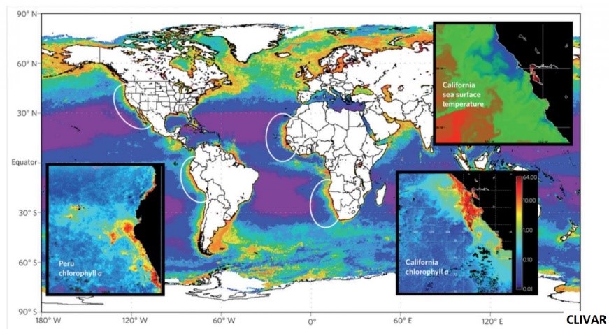 Figure 2: Major upwelling area in the world’s ocean (image adapted from CLIVAR website).
Upwelling in the east coast of Peninsular Malaysia
The upwelling phenomenon in the east coast of Peninsular Malaysia (ECPM) is only to be discovered after 20s. During the southwest monsoon from June to September, the alongshore blowing southwesterly winds with north-south orientation coastline along the ECPM are favorable for the upwelling. The upwelling area in the ECPM is represented by a patch of cooler water that stretching from Tanjung Penyusup, Johor to Dungun, Terengganu with a maximum width of about 100 km offshore. The upwelling intensity is increasing from June and reach its peak in August before dwindling in September according to the wind speed variations during the southwest monsoon.
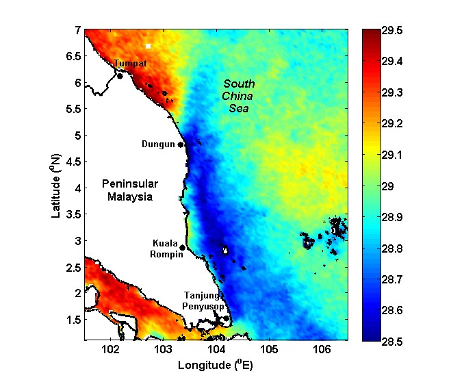 Figure 3: Averaged sea surface temperature during the southwest monsoon. Upwelling area in the ECPM is characterized by cooler water extended between Tanjung Penyusop, Johor and Dungun, Terengganu.
Upwelling in the ECPM is proved to promote phytoplankton growth as indicated by the increment of chlorophyll-a concentration during the southwest monsoon associated to the nutrient enrichment in the surface waters. The intensification of the phytoplankton growth in the ECPM actually provide a conductive area for spawning, nursing and feeding ground for fish, which results in the marine fish landing during the southwest monsoon tend to be higher than the northeast monsoon (November to March).
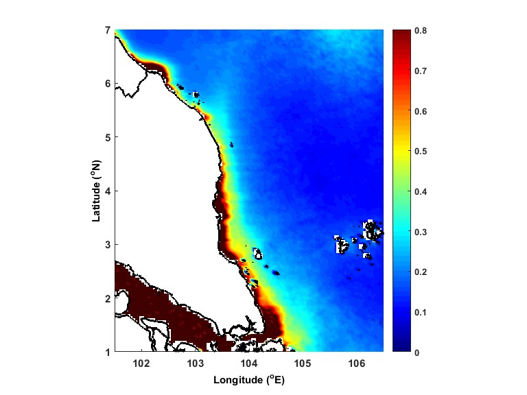 Figure 4: Averaged Chlorophyll-a concentration during the southwest monsoon. Upwelling promote phytoplankton growth along the ECPM which is necessary for the wide range of marine life especially for fish.
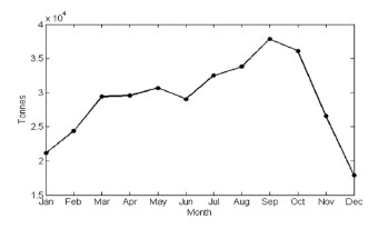 Figure 5: Monthly marine fish landing in the east coast state of the Peninsular Malaysia (West Johor, Pahang, Terengganu and Kelantan). Upwelling during the southwest monsoon caused an increase of marine fish landing.
Reference
Ryther, J. H. (1969). Photosynthesis and fish production in the sea. Science, 166(3901), 72–76. doi:10.1126/science.166.3901.72
About the author


